Travertine? Never heard of it? Is it an indie band? Is it a type of floor covering? Is it an errant world-traveler? Actually, none of those. Actually, if you don’t know what it is, that might just point to the fact that you’ve never visited Pamukkale in Turkey. For if you had, that’s where you’d have learned that this, is travertine! ->
The terraces of Pamukkale, which means “cotton castle” in Turkish, are without a doubt among the most beautiful and unique natural objects on our planet (so, of course, they feature in my Top-100 Most Beautiful Places in the World). The travertine is the sedimentary rock deposited by mineral water at the exits of the hot springs here that has formed a colossal cascade of pools with stalactites hanging down off them – and everything as white as snow.
Across desolate desert we drove, down Skeleton Coast we cruised, over dusty dunes we danced. All a bit… dry. It was time for something very wet. And it can’t get much wetter than the Victoria Falls in Southern Africa, so that’s just where we were headed next – on the border between Zambia and Zimbabwe.
Victoria Falls aren’t the largest or tallest waterfalls in the world. Nor are they the most powerful in terms of flow rate. However, they do come out the clear winner in another category – the area of the falling water: around 1.8km at ~100+ meters. Which adds up to a most grandiose body of falling water – especially when the level of the Zambezi River is high during rain season. Meanwhile the mid-level water looks like this:
A bit like with the Valley of Death, though its name is macabre and ominous, Deadvlei couldn’t be more beautiful! The locals realize this too, for this here ‘Dead Marsh’ clay pan with its dead forest upon it is the ‘business card’ of the country: any search on the internet for anything at all about the country returns photos of the place.
The trees, though dead, really are striking, especially given such a vast barren backdrop. You can meditate upon them, in-between taking photos of them, for ages. Which we did…
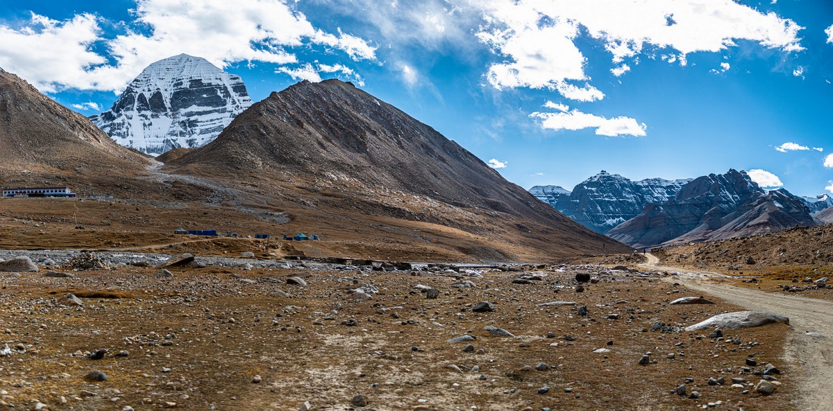
After a sound, albeit short night’s sleep after two intense days on the road getting here, it was finally the morning of the day of the first leg of our kora around Mount Kailash. ~20 kilometers of trekking was on the menu for us this day, with a rise of ~350 meters in altitude (from ~4700 to 5000+). We were walking from dawn till dusk, which translates into around nine hours! Yes – more tourism until you drop: just as we like it ).
Our objective for the first day: to get a sighting of the northern slopes of Kailash from the direction of Dirapuk Monastery.
On our Tibetan adventure – onward; and today, our heads turned categorically – upward! Upward to one of my Top-100 Most Beautiful Places on the Planet, which happens to be the highest place on the planet: Sagarmartha, aka Chomolungma, aka Zhumulangma, aka Mount Everest! Oh my giant! Here she is, from the northern (Chinese) side, through a good long-distance lens (photos – DZ) ->
A little further, at dawn:
Further still – at sundown:
So, Everest is the tallest mountain in the world; everyone knows that, right? Thing is…
…It actually depends on how you calculate highest/tallest. Furthest above sea level? Furthest from the center of the earth? Or the highest peak of a mountain from its base? If we use ‘furthest from the center of the earth’, the highest point on the planet is Chimborazo in Ecuador. Its peak is a full 3.5km (!) further from the center of the earth than Everest. And if we take the ‘world’s highest mountain’ as the tallest mountain from its base to its peak, then the Hawaiian Mauna Kea wins: above sea level it clocks in at 4205 meters, but there are a further four to five kilometers of it under the ocean! That makes its total height some 10 kilometers! Locals in Hawaii even state it really is 17km high (!), since the weight of the volcano pushed the tectonic plate under it down by ~7km! More details – here.
But the true champ really is – as we all know – Mount Everest! It’s peak is the highest point in the world; the air pressure up there is the lowest on the planet; and from the center of the earth it is – after all – the highest mountain. It’s not a volcano ).
And that’s where we were headed – to Everest. Not up it – that is a feat requiring months of training; but at least to see it from down below. The first sign we were getting close to it was when we passed through these here gates – into Qomolangma National Nature Preserve (Qomolangma being the Tibetan name for Mount Everest).
That was the first gate; there’ll be more to come. Meanwhile we’re taking this here beaut-route:
Another gate; base camp – this way…
We had our documents checked (as we were used to by now), and then had a 90km drive ahead of us – to the protected territory, where we’d have to transfer to local busses to take us the last 20km to the base camp. Like this.
Here’s the mountain pass where we caught our first glimpse of none other than Mount Everest!
Hypnotic scenes…
Sunset!
The colors change every minute!
One thing stays lit up by the sun after everything else is already in the shade – Mount Everest, of course ).
Here some of DZ’s kit taking a time-lapse vid:
And here’s the resulting time-lapse:
Duly hypnotized, no one was there to wake us from our hypnotic state – we were well and truly entranced! Actually, eventually our guide did manage to bring us round – with his almost hysterical exhortations for us to get going as it would soon be dark…
Sundown shade from the mountains!
It’s getting brighter and brighter!…
I’ll hand the reins over to DZ for the photos of Everest…
boris_prok informs us that besides Everest there are another three 8000m+ mountains here! And here they all are ->
And if you have a lens powerful enough – you can get a pic of the fifth 8000er – Shishapangma (8027m):
We arrive. Er, and find out we’ll be staying the night in these here tents/huts ) ->
Actually, once inside – perfectly fine: cozy, warm, clean.
Though very tired after such a long day, we simply had to go walkabout up here – so much closer than usual to the stars…
We were up at the crack of dawn – and it was out with the cameras again for the extraordinarily beautiful daybreak…
Here’s us lot – waiting for the first rays of sun…
The eastern slopes, as can be expected – start to brighten…
Direct sunlight – yes!
Other mountaintops also light up!
Good morning Everest!
Time-lapse!
The view seizes you, and doesn’t let go!
The green bears love the morning view too!
But we need to get back to the camp and plan our day…
Thus, the second thing we were to see that day was Rongbuk Monastery – the highest (Buddhist) monastery in the world.
The monastery is small, so doesn’t take long to give a full inspection. There’s not much to say about the place either, but – you are allowed to take photos!…
At the entrance, in addition to fire extinguishers – oxygen apparatus!
This is where climbs to the stop start out. It’s eight kilometers to the south of Everest, at the foot of Rongbuk Glacier. I’d love to come back here and simply walk around for a day or two. But climbing Everest? No thank you; not for me. I’m a volcano man, don’t forget ).
Unsold trinkets, and oxygen cylinders – frozen to the table! ->
As many of you will know, I have a special list of what are to me the most beautiful – must-see – places on the planet. I call it my Top-100, and it’s updated regularly – here. I haven’t been to all of the places on the list, but I do add checks against some of them often – to put them into the ‘been, seen, snapped, etc.’ sub-category of the list. Just this year I’ve been, seen and snapped: the Galapagos Islands;Lake Baikal; the most beautiful volcanoes in the world (on the Kuril Islands); perhaps the clearest, bluest sky in the world (also – Kurils); the Gobi Desert (hmmm: not on the list, but will be soon after a touch of rearranging/editing:); Baalbek; and the stone miracles of Cappadocia. And just the other week – my newest check against an entry: Potala Palace, Lhasa, Tibet – both day and night, no less.
And here she is (“Oh – that palace!” I can hear many of you thinking:) ->
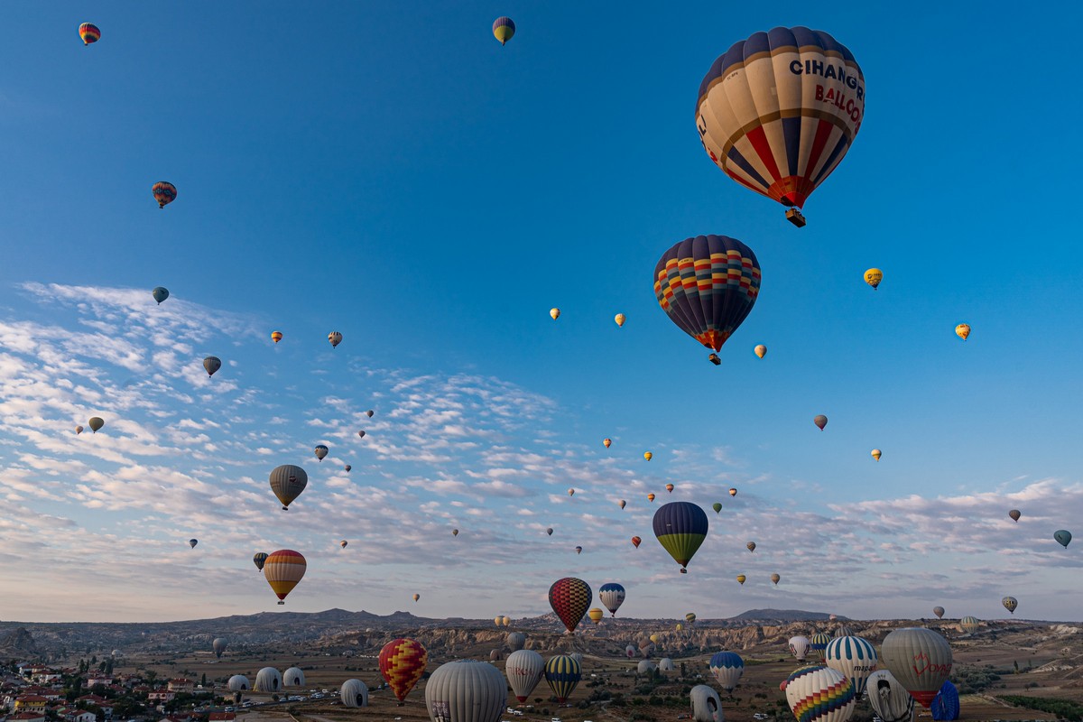
If you’ve heard of Cappadocia, you’ll probably know it for one of two things – or maybe both: its strange-shaped pyramid-columns, or (and) the many hot-air balloons that often fill the sky there. Well I’d heard of the place, but had never been, but wanted to for a very long time. The place even has a spot in my Top-100 Must-See Most-Beautiful Places in the World, so it was high time I made a visit seeing as though I was in the region recently…
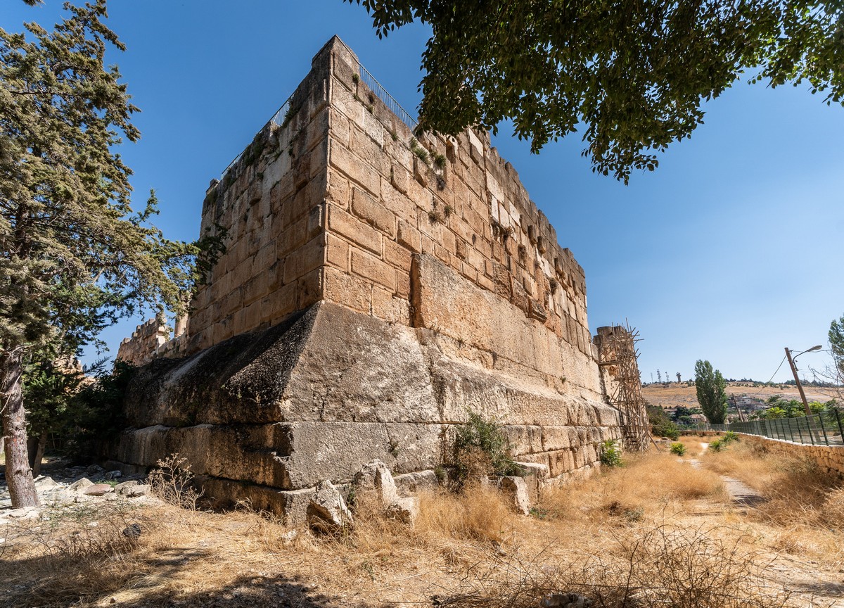
Perhaps the first question that comes to mind for anyone who visits Baalbek is: who placed all these massive stones here, when, why, and how? Ok, ok: the first four questions ).
The stones are gigantic: almost too big to fit in a photo!
Been a while, I know. What can I say? Actually – three words: July and August :).
I’m literally just back from yet another oh-my-gripping summer expedition – this time around the Kuril Islands (the string of islands above Japan at the far-eastern end of Russia, just in case geography ain’t your strong point). Actually, I could say I’m just back from two trips along the full length of the Kurils (I’ll explain quite why later on): from Kamchatka at the northern end; right down to the southern end; over to Sakhalin; back over to the southern-most Kuril island of Kunashir; and back up to practically the northern-most Kuril island of Atlasov right next to Kamchatka again; plus – bonus track – a quick trip to the Commander Islands to the east of Kamchatka (not far Alaskan islands).
In all, around a dozen islands were visited (some of them – twice), walked upon, and snapped aplenty with my trusty Sony. Approximately seven volcanoes were observed up close (again – some twice), but alas Tyatya we didn’t manage to inspect due to poor weather. In all, the intensity of the impressions: off the scale. Back here in Moscow, I’m still swaying on my feet occasionally, for we were a full month living on a small ship out at sea – and that includes every night bar a few (in Yuzhno-Sakhalinsk and on Kunashir and Onekotan). The number of photos and videos shot from the ground and up in the air (using drones) – oh my: countless. Accordingly, I’ll be uploading portions thereof gradually as I get through them, accompanied by my traditional tales from the road ship, volcano, and other wild places of interest less-visited…
The other week I had a quick – six day – outing over to Lake Baikal in Siberia. As could have been expected, it was a delightful trip, with the six days passing so quickly it was as if time itself had been shortened. Ice, snow, endless expanses, entrancing enjoyment. And – oh my gigabytes – a ton of photos we appear to have taken. Ok, while I’m sifting, selecting and editing, I’ll give you some traditional aperitif-pics to whet the appetite…