April 9, 2018
Tag Archives: top100done


January 26, 2018
At Borobudur – check out the sunset for sure.
After our strenuous scaling of Merapi, we decided to lower the intensity a bit, and move from volcanism to Indonesian culture. Accordingly, next up: Borobudur – the world’s largest Buddhist temple.
The temple consists of several stacked platforms; the lower levels are square (with 100-meter-long sides), while the upper ones are round. “At the very top of the temple is a large dome. It is decorated with 2672 relief panels and 504 Buddha statues. The central dome is surrounded by 72 Buddha statues, each seated inside a perforated stupa.” – Wikipedia.
Here‘s the view of the whole complex from a satellite, while this is how my camera captured the temple:

January 18, 2018
An equatorial New Year: further from the center*.
Hi folks!
I’ve been back home a good few days already. I caught my breath and laid low for a bit to recharge the batteries, and then the working year kicked off. But most importantly I sifted through all my recently-taken pics to organize them for my upcoming mini-series: this time on our New-Year-holidays adventure in the jungles of equatorial-tropical Indonesia…


For a full 18 days our posse navigated land, water, air and… volcanoes (naturally), practically without any rest or taking-it-easy at all: ‘tourism til you drop’ – just as I like it. Our guide, O.R., summed it up nicely: ‘And you thought you came here to relax?!’.
December 28, 2017
The full Ha Long.
I’ve been on a pretty tight business schedule and haven’t had much free time. Now, I’ve got a backlog of stories that I have to publish about the places I’ve visited and the sights I’ve seen – and the backlog keeps growing, which I don’t like. So, I’ll try and catch up whenever I have a spare moment and functioning Wi-Fi, which may be a bit of problem in the foreseeable future.
So, I’m in Vietnam, at Ha Long Bay, which is here. This is, without a doubt, one of the wonders of the world, definitely worth a visit – just like all the other entries in my Top-100 Must-See Places in the World. I was last here in May 2010, and now I’ve just revisited. And I don’t regret it for a second.


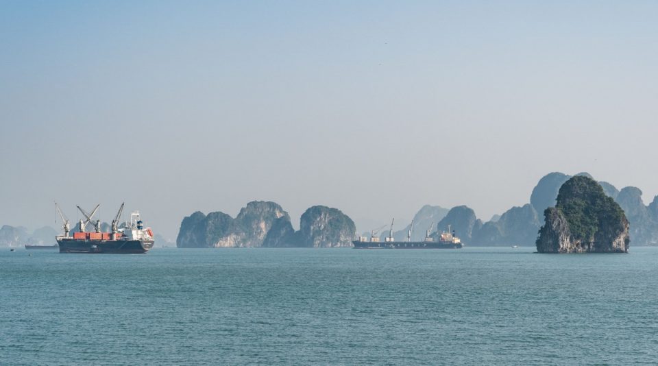


Read on: what have been changed during the last seven years…
November 3, 2017
Old Model Army.
Nihao folks!
Onwards we fly on our China-2017 tour… Next stop: the city of Xi’an – pronounced Si-an – meaning ‘western peace’.
It was a nice day, which is just as well, as there’s plenty to do and see in and near the city. Our itinerary went so: city walls and the old town; ancient pagodas; and (not far from the city) Mount Hua – one of the Sacred Mountains of China. Anyway, more on those later. For now, the Terracotta Army, no less!


You may have heard of this UNESCO World Heritage Site of funerary art; yes, it is quite famous. But the unexpectedly fine detail and massive scale of the mausoleum are only really grasped when you see it in the flesh. A truly grandiose historical site.
October 31, 2017
Lijiang: few words, many photos – pt. 1.


October 22, 2017
Up at the crack of danxia.
Hi folks!
Herewith, I continue may tales from the Chinese side…
As per the template, this won’t be a simple photographic mini-series with explanations of the pics, but also a how-to guide for folks who might want to visit the place one day themselves, which, as is often the case, I heartily recommend.
Today I start with the Danxia landforms. Now, Danxia in Chinese means ‘red hills’; that is, any hills that happen to be red or reddish-colored. And in China there are dozens of different sets of red hills all over the southeast, southwest and northwest of the country. However, there is a specific Danxia Shan – Mount Danxia (confused?!). I wonder what came first – the egg or the chicken Danxia – the mount, or Danxia – the general term for red rock formations in China? The internet returns contradicting results. And locals don’t seem to know themselves. In short: one of China’s many mysteries.
Btw, Danxia is pronounced ‘Dansya’. Danxia isn’t an English term; it’s Chinese in the Latin alphabet – pinyin. There!
So, where do I begin my narrative? There are so many options – so much to show. Ok, let’s keep it simple and logical – let’s start with the break of dawn…


September 26, 2017
Ready, set, get Iguazu wet.
Hi folks!
As promised, herewith, more from the best stretch of the Argentina-Brazil border.
There’s a good reason why it’s ‘falls’ – in the plural. Apart from the obvious fact that this is for sure a collection of waterfalls all together – some to the east, some to the left, others to the north and south – you can also split the falls in two geographically-politically: some of them fall (pun unintended) in Brazil; the others – Argentina. You can see how on the map: the border between the two countries runs down the middle of the Iguazu River. Anyway – the views from each country are totally different. From Brazil it’s all about panoramic views and water cascading down. From the Argentine side: a spectacle of the almighty power of the waterfalls. There’s also cascading water – only you view it from up top. But enough words; enter the pics!..
So, here we go: first up – Brazil:


August 29, 2016
Altai-2016: The Big Water Trail.
Hi all!
Altai ranks up there as one of the most fascinating and magical places on earth.
It’s not only beautiful – there’s something about the place. It might be some sort of special energy in the rocks there or something else unbeknown to us. Here the colors are brighter, the water tastes better, the grass is greener, and the mountains contrast more with their surroundings. This year I was lucky enough to spend three weeks in Altai with a group of like-minded adventurers. We hiked, choppered, and rafted (down the Katun River).


In all we walked about 70 kilometers to Lake Akkem and then around it, flew around mount Belukha in a helicopter, flew up to the headwaters of the Katun and rafted down to the lower reaches of the river – almost 400km (four HUNDRED kilometers!!) in all, and descending over a kilometer along the vertical axis. This was my ‘summer holiday’.
July 22, 2016
Greenland, pt. 7 – Glacialicious.
As promised yesterday, here come a LOT of photos…
So get the popcorn in plus your beverage of choice, and we’re off…


