September 28, 2019
On Lovushki – scenes surreal: a paradise for the seal!
Hi folks!
The topic of today’s post – these cute little charmers:
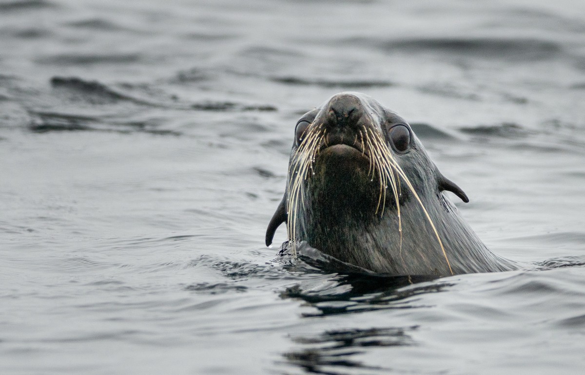
https://www.instagram.com/p/B1olBCjAUGA/?utm_source=ig_embed
But first, some intro….
NOTES, COMMENT AND BUZZ FROM EUGENE KASPERSKY – OFFICIAL BLOG
September 28, 2019
Hi folks!
The topic of today’s post – these cute little charmers:
https://www.instagram.com/p/B1olBCjAUGA/?utm_source=ig_embed
But first, some intro….
September 24, 2019
The islands of Atlasov, Paramushir, and Onekotan – already inspected. So what was next on our southward trajectory along the Kurils? Well, there was plenty to go on: there were another 50+ islands left! However, not all of them are interesting. For example, just south of Onekotan (with its Krenitsyna) there’s the island of Kharimkotan. Here it is in fine weather:
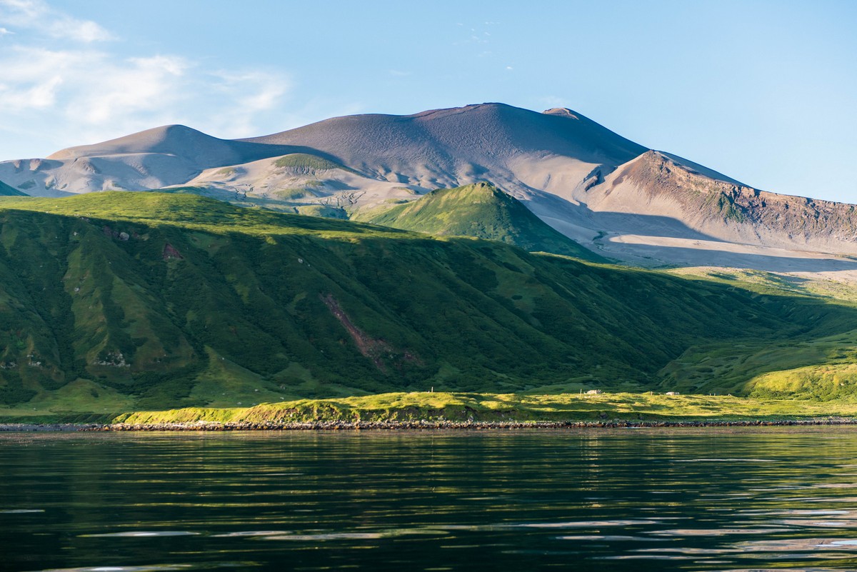
And here it is on Google Maps.
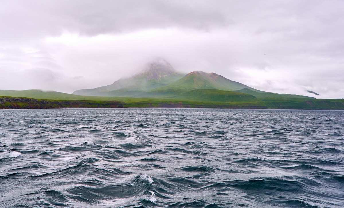
September 20, 2019
Hi folks,
Onward I narrate about our expedition round the Kurils this summer…
The weather on the Kurils is unpredictable, for sure. For most of the previous two days, up on the caldera of the King of the Volcanoes, the weather couldn’t have been pleasanter. This day, on the other hand – just the opposite: the wind was blowing a gale, and the rain was pouring down in torrents. Still, I won’t go over the wicked Kurilian weather again; I’ve mentioned it plenty before, including here. Nothing to add – apart from the fact that nothing has changed ).
Anyway, on this day of hurricanes-and-raining-cats-and-dogs, we had planned an inspection of Onekotan‘s Nemo Peak, and possibly even a climb to the top of it, since it’s not so tall (a little over 1000 meters). However, the weather failed to grant us permission (.
September 14, 2019
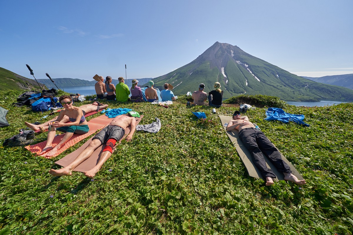
It’s hard to believe, but in the northern Kurils there are only two or three days of sunshine – per year! No, really! Therefore, if ever you find yourself sat on the edge of the outer caldera of Krenitsyna Volcano, and the sun is shining – savor every single second, as we’re doing here in this pic – because you could be weeks waiting for the next short-lived installment of fine weather.
September 11, 2019
Let’s say you’re near the top of Krenitsyna Volcano in the Kurils, you’ve applied the Strategic Stratovolcano Stratagem to secure some imminent sunny weather, you have tents with you, sleeping bags and gas stoves (no firewood up there) and all the rest, which you’ve carried with you 500+ meters along the vertical and 9km on foot (7.5km to the edge of the caldera; 1.7km to the pond), you dump it all down on the grass (or put up the tents straight away if the weather’s still poor), sit on the very edge (ideal spot – very comfortable) and are ready to behold the most mind-blowingly picturesque volcanic scene on the planet…
So, what next?…

Next, you just sit and wait. Everything will work itself out. Namely, that just-mentioned most mind-blowingly picturesque volcanic scene on the planet slowly but surely comes into full view. Oh my grandiose! Then, you just stay sitting there, unable to tear your eyes away from it – as if you’d want to ).
September 8, 2019
Hi folks!
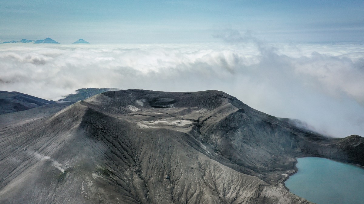
Herewith, a continuation of my narrative about the most beautiful volcano in the word, the king of all volcanisms on the planet (and in the Solar System, surely:) – his royal highness Krenitsyna Volcano! Here he is:


August 31, 2019
Now we’re done with the northernmost Kuril islands, and it’s time to head south. On the right hand side, we see two islands Antsiferov and Makanrushi. I’ve not heard anything interesting about these two, which is why we pass them by without calling in; perhaps there is something worth seeing that I don’t know about. If anybody knows of something worth seeing on those islands, let me know and I’ll try and visit them next time I’m around this way.
Next on our Kurils route comes sunny Onekotan, a truly remarkable and delightful place! What makes it so special is the Krenitsyn volcano, the most beautiful volcano in the world, positioned at the island’s southern tip. No words or comments can match its beauty… This is the king of all volcanos! A stunning creation. Oh… and there I was trying to steer clear of “words or comments”. Even just looking at these pictures, it takes your breath away… Wow!


August 28, 2019
And here we are again on the northern Kuril island of Paramushir. Most of our group of intrepid tourists spent this sunny summer morning climbing the slopes of the Ebeko volcano in search of adventure and an adrenaline rush, while the others stayed in the town of Severo-Kurilsk at the base of the volcano. Actually, most of those who stayed behind had already jogged struggled to the top last time in the pouring rain. You can also follow that link to read my impressions of the northern Kuril weather and climate. Anyway, for the smaller part of our group that wet and windy climb five years ago was still fresh in the memory, and we decided to stay and enjoy the creature comforts of town life. Here I’ll be sharing their photos, especially as this remarkable town is likely to be too difficult and too expensive to visit for many.
And here you have sunny Severo-Kurilsk:


August 22, 2019
The next northern Kuril Island on our expedition was Paramushir. If you look southwest from Kamchatka you can’t miss it – dwarfing, and just to the left of, tiny Atlasova where we were the previous day. It’s more than 100km in length and up to 30km across. The whole of the island’s surface is covered in volcanism both old and new – and very active, with its main volcano having erupted as recently as in 2016. That volcano was Ebeko – whence came the towers of smoke and ash we saw back in 2018 over on Kamchatka while walking along the shore of the Sea of Okhotsk.
To climb up Ebeko on a clear day had been a dream of mine ever since we made it to the top in 2014 in horrendous conditions: cold, wet, windswept, and visibility down to next-to-nothing. But this year – just the opposite: warm, dry, windless, and visibility up to scores of kilometers. Hurray!
First – a bit of factual background on Ebeko. It’s a stratovolcano of a multi-faceted structure with several craters at the very top. In fact, the topology of the volcanic activity is so complex that one of the craters was found to be a separate, independent volcano. Not that that really matters. The main thing was that it was a clear sunny day; that meant one thing – we were off up Ebeko and it was going to be a heavenly experience!
This is where we were headed:
August 20, 2019
If the internet is to be believed, there are a total of 56 Kuril Islands, not including the many separately standing and/or grouped rock formations. In all I’ve walked upon 14 Kurils, which doesn’t sound much; however, I chose well – they’re among the most interesting.
As I mentioned earlier, we were going from the northernmost to the southernmost Kurils. The first, northernmost Kuril is Atlasov Island, which is basically a volcano-island, the volcano itself being called the Alaid (pronounced A-la-eed).
The Alaid is 2285 meters high, making the island not only the tallest of all the Kurils – but also of all Russian islands (didn’t know that; isn’t the internet just great?:). And since the depth of the Sea of Okhotsk around these parts is around 800 meters, the total height of the volcano from the bedrock under it is a full three kilometers. An impressively colossal construction!
But enough of statistics. The main thing about this volcano-island is how it looks. It’s just so smoothly spherical. So much so, our guides told us how many Japanese who visit say it’s even more beautiful than their sacred Mount Fuji!
I could write at length describing the stunning symmetry of Atlasov-Alaid, but, as I often say, why bother when I’ve lots of photos – plus a video (of the time-lapse variety, no less)?! Here you go ->