Early June of 2019 was a quiet, nothing-special kind of early June. The world was rotating around the Sun as per, 19 days remained until the astronomical summer, ‘Corona’ meant a Mexican beer, and ‘covid’ meant absolutely nothing to anyone. In short, it was life as we knew it pre-pandemic: what we all could do with a lot more of today…
Meanwhile for the Kompany, we had our own schedules and timeframes, also as per. And early June, 25 months ago on our schedule was significant: it was when our big rebranding was taking place. The time had come for us to say goodbye to the old Korporate style (in terms of the logo, besides a whole lot of other stuff, including the fonts and other stylings and colorings and imagery, and what-have-you), which, given a few tweaks down the years, had been with us a full 22 years! It was out with the old and in with the new – a reboot, an upgrade, a Porsche, a rejuvenation, an image change; time for something different, more in line with the times, and also more polished; at least that’s what I was told (joke). No, really – it was to give us a new corporate style to more accurately reflect the company’s next stage of development – an ambitious yet confident stage, and certainly a futuristic one given our industry (cyber [the security thereof]).
But where others change their logo (slightly!) and have done with it, we had lots more in store. In fact, a full rebranding is a lengthy, complex process of tweaking perfecting all aspects of the identity and life of the company, including not only how we look on the outside, but also the way we interact with audiences, communication style, and scores of other things.
So yes; today’s post is all about rebranding. Now for some detail…
Work on our big rebranding began back in 2018. We’d known for a while how our good old logo/brand and messaging were more late-90s/early-2000s-oriented than 2019. For years we’d been sensing a certain dissonance between our technologies/products – which were always truly cutting-edge – and the image of the company to our users. For several years already we’d not been ‘just an antivirus company’ but a developer of broad-spectrum cybersecurity solutions. Yet still our logo was fairly antique with its pseudo-Greek letters. It was as if it was anchoring the company to the past – to the long-forgotten floppy-disk times.
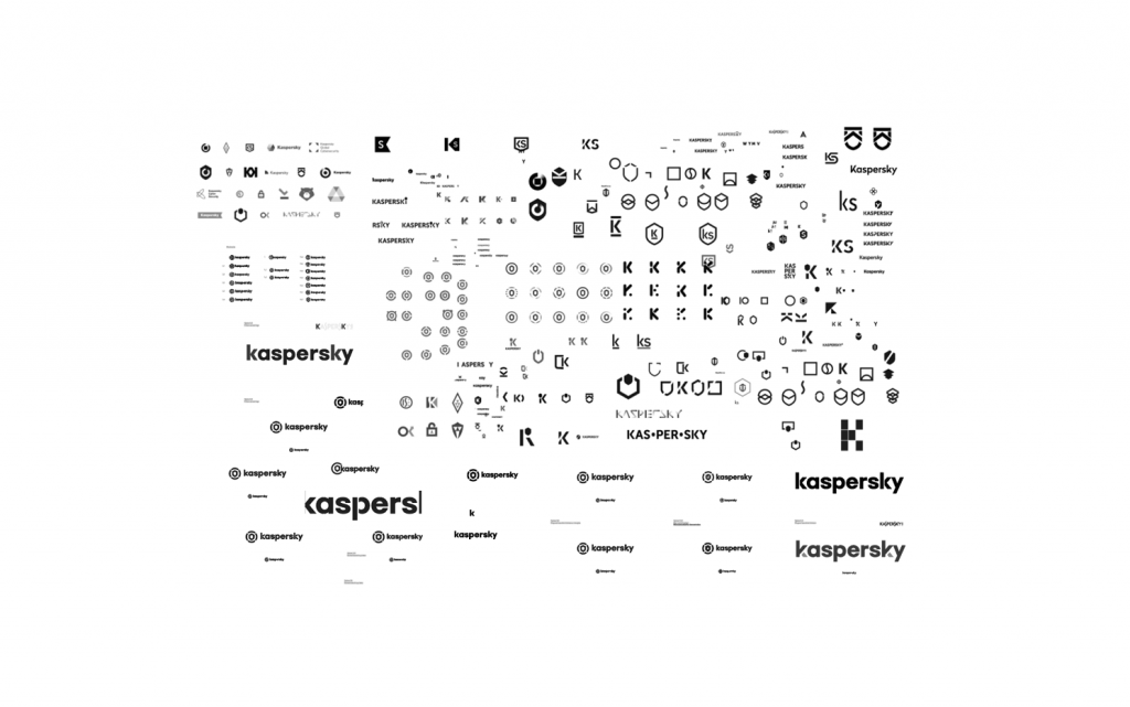
For nearly a year we brainstormed, thought, compared, imagined, weighed up, discussed, argued, consulted, agreed then disagreed, considered, debated, deliberated… all so as to find the very best perfect fit for our rebranding. A conservative estimate at the number of logo variants our design team put forward gives at least… 300! Then, the final couple of candidate-versions were vetoed be moi. Not because I was being obstinate, but because I was being super obstinate simply didn’t see even in those final few prototypes one that resonated 100% with the company’s aims and values.
Oh, and here are the rejected variants! ->
Some curious near-misses (hits?!) occurred during the year of debate…
Read on…