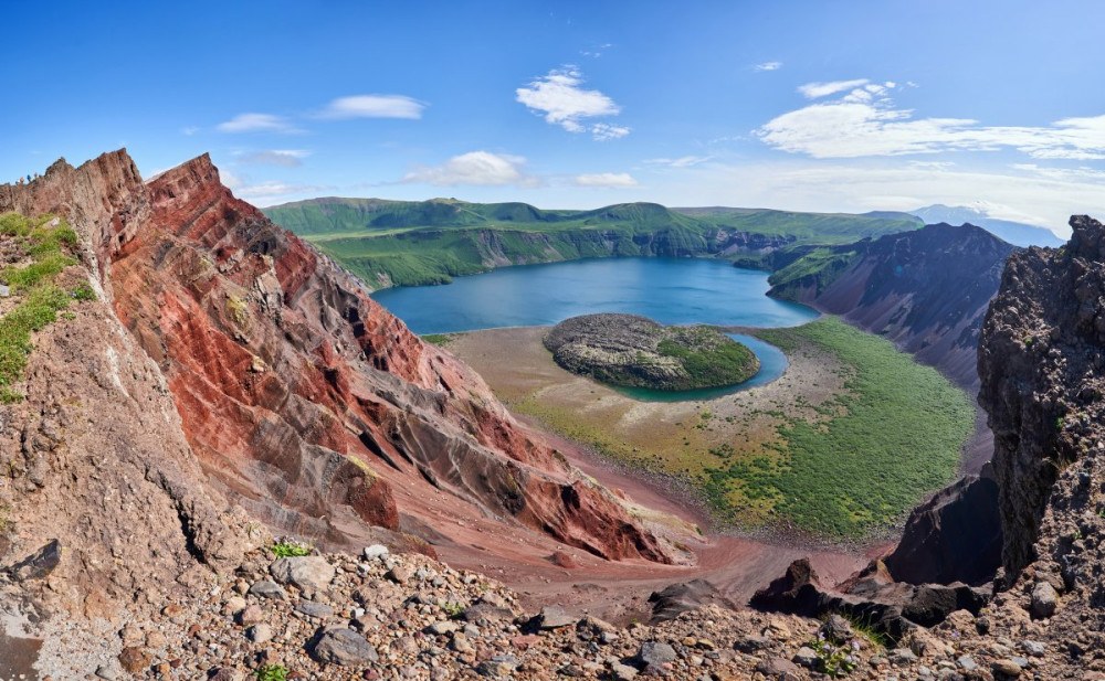
Tag Archives: must see

Victoria Falls 2020.

Across desolate desert we drove, down Skeleton Coast we cruised, over dusty dunes we danced. All a bit… dry. It was time for something very wet. And it can’t get much wetter than the Victoria Falls in Southern Africa, so that’s just where we were headed next – on the border between Zambia and Zimbabwe.

Victoria Falls aren’t the largest or tallest waterfalls in the world. Nor are they the most powerful in terms of flow rate. However, they do come out the clear winner in another category – the area of the falling water: around 1.8km at ~100+ meters. Which adds up to a most grandiose body of falling water – especially when the level of the Zambezi River is high during rain season. Meanwhile the mid-level water looks like this:

Read on…

Ghosts of Lehrer, Buchhalter, Minenverwalter and other adventures in ghostly Kolmanskop.

The next destination on our Namibian tour and the main reason for going to Lüderitz is the ghost town of Kolmanskop.

The settlement sprang up around the diamond fields, went through a period of rapid growth, then the diamonds dried up and the town was abandoned. Now this once-thriving town is almost buried in the desert sand and is gradually eroding, leaving behind some apocalyptic images.

Welcome to Kolmanskop! Open from 8 A.M. to 1 P.M., entrance fee, drones forbidden.

Read on…

Flickr photostream

  • Lake Garda
  • Lake Garda
  • Lake Garda
  • Lake Garda

Instagram photostream

A hot day at Deadvlei.

A bit like with the Valley of Death, though its name is macabre and ominous, Deadvlei couldn’t be more beautiful! The locals realize this too, for this here ‘Dead Marsh’ clay pan with its dead forest upon it is the ‘business card’ of the country: any search on the internet for anything at all about the country returns photos of the place.

The trees, though dead, really are striking, especially given such a vast barren backdrop. You can meditate upon them, in-between taking photos of them, for ages. Which we did…

Read on…

Enter your email address to subscribe to this blog

Ok girls and dudes – time for some dunes.

The famous dunes of Namibia – in the Namib desert – were the ‘main dish’ of our Namibian trip. The dunes have been on my Top-100 Most Beautiful Must-See Places on the Planet, I think since I first drew it up. I’d long… longed to get there, and finally, early this year – I did it!

As I’ve already reported, the Namib is one of the driest places on the planet, with a mere centimeter of rain falling PER YEAR! As you’d expect, accordingly, hardly anything grows here at all. Oh, and another thing about the Namib – it’s the oldest desert in the world! If the internet is to be believed, it is 50-80 million years’ old! That is, it’s had dinosaurs roaming upon it! One more thing: in the local tongue the name Namib means ‘vast’. Indeed it is. Vastly beautiful too ->

This dune here happens to be one of the highest in the world – nearly 400 meters from top to bottom!

Read on…

African Adventure 2020 – Namibia: day two – Skeleton Coast.

Our second day in Namibia started very early – before the crack of dawn even. We were showered and packed before breakfast in the hotel was served. And this early-bird tendency stayed with us throughout the whole trip. Then, after our breakfast of a morning would follow concentrated levels of tourism, planned perfectly (or as near as darn it) so that we’d arrive at our next hotel (rarely the same hotel twice) around dusk, shower, have supper, and turn in for the night. Clockwork, basically ). Repeat 10 times! We call it ‘tourism till you drop’. And it suits us just fine!…

So. Day two: dedicated completely to Skeleton Coast

Read on…

Diez cenotes, o, cenotes sobredosis!

Ingredients: the Yucatan peninsula; three free days between business events; a great desire to check out cenotes and bathe in them.

Something to be factored in: No Rio Secreto this time; been there a few times, done that, swum that – without the t-shirt.

Decision: Uno, dos, tres – let’s check out 10 cenotes!

There are four types of Cenotes: Cantaro (a cave with a hole in the roof thereof); cilindricos (with strictly vertical walls); aguagas (with shallow water basins); and grutas (cave cenotes, with a horizontal entrance with dry sections). Now, for some reason, along the coast of Yucatan there are mostly the latter to be found – grutas, while if you drive further from the coast inward they are overtaken by cantaro. Why, I don’t know.

Anyway, we set off to study the cenotes in the Dos Ojos park. Here, there are a full 28 cenotes, with around 10 accessible to folks for entering and bathing in. Apparently all the cenotes are part of one and the same system and interconnected as a single labyrinth (underwater river) – which runs to a total length of… 80 kilometers! And it’s all just 15km from Tulum.

Sources

All righty. Off we go – to Dos Ojos…

Read on…

A three-day kora around Kailash.

Hi folks!

After a sound, albeit short night’s sleep after two intense days on the road getting here, it was finally the morning of the day of the first leg of our kora around Mount Kailash. ~20 kilometers of trekking was on the menu for us this day, with a rise of ~350 meters in altitude (from ~4700 to 5000+). We were walking from dawn till dusk, which translates into around nine hours! Yes – more tourism until you drop: just as we like it ).

Our objective for the first day: to get a sighting of the northern slopes of Kailash from the direction of Dirapuk Monastery.

Read on…

Tibetan autumn: the world’s highest (non-volcano) mountain.

Hi folks!

On our Tibetan adventure – onward; and today, our heads turned categorically – upward! Upward to one of my Top-100 Most Beautiful Places on the Planet, which happens to be the highest place on the planet: Sagarmartha, aka Chomolungma, aka Zhumulangma, aka Mount Everest! Oh my giant! Here she is, from the northern (Chinese) side, through a good long-distance lens (photos – DZ) ->

A little further, at dawn:

Further still – at sundown:

So, Everest is the tallest mountain in the world; everyone knows that, right? Thing is…

…It actually depends on how you calculate highest/tallest. Furthest above sea level? Furthest from the center of the earth? Or the highest peak of a mountain from its base? If we use ‘furthest from the center of the earth’, the highest point on the planet is Chimborazo in Ecuador. Its peak is a full 3.5km (!) further from the center of the earth than Everest. And if we take the ‘world’s highest mountain’ as the tallest mountain from its base to its peak, then the Hawaiian Mauna Kea wins: above sea level it clocks in at 4205 meters, but there are a further four to five kilometers of it under the ocean! That makes its total height some 10 kilometers! Locals in Hawaii even state it really is 17km high (!), since the weight of the volcano pushed the tectonic plate under it down by ~7km! More details – here.

But the true champ really is – as we all know – Mount Everest! It’s peak is the highest point in the world; the air pressure up there is the lowest on the planet; and from the center of the earth it is – after all – the highest mountain. It’s not a volcano ).

And that’s where we were headed – to Everest. Not up it – that is a feat requiring months of training; but at least to see it from down below. The first sign we were getting close to it was when we passed through these here gates – into Qomolangma National Nature Preserve (Qomolangma being the Tibetan name for Mount Everest).

That was the first gate; there’ll be more to come. Meanwhile we’re taking this here beaut-route:

Another gate; base camp – this way…

We had our documents checked (as we were used to by now), and then had a 90km drive ahead of us – to the protected territory, where we’d have to transfer to local busses to take us the last 20km to the base camp. Like this.

Here’s the mountain pass where we caught our first glimpse of none other than Mount Everest!

Hypnotic scenes…

Sunset!

The colors change every minute!

One thing stays lit up by the sun after everything else is already in the shade – Mount Everest, of course ).

Here some of DZ’s kit taking a time-lapse vid:

And here’s the resulting time-lapse:

Duly hypnotized, no one was there to wake us from our hypnotic state – we were well and truly entranced! Actually, eventually our guide did manage to bring us round – with his almost hysterical exhortations for us to get going as it would soon be dark…

Sundown shade from the mountains!

It’s getting brighter and brighter!…

I’ll hand the reins over to DZ for the photos of Everest…

boris_prok informs us that besides Everest there are another three 8000m+ mountains here! And here they all are ->

And if you have a lens powerful enough – you can get a pic of the fifth 8000er – Shishapangma (8027m):

The serpentine road is almost as impressive! ->

We arrive. Er, and find out we’ll be staying the night in these here tents/huts ) ->

Actually, once inside – perfectly fine: cozy, warm, clean.

Though very tired after such a long day, we simply had to go walkabout up here – so much closer than usual to the stars…

We were up at the crack of dawn – and it was out with the cameras again for the extraordinarily beautiful daybreak…

Here’s us lot – waiting for the first rays of sun…

The eastern slopes, as can be expected – start to brighten…

Direct sunlight – yes!

Other mountaintops also light up!

Good morning Everest!

Time-lapse!

The view seizes you, and doesn’t let go!

The green bears love the morning view too!

But we need to get back to the camp and plan our day…

Thus, the second thing we were to see that day was Rongbuk Monastery – the highest (Buddhist) monastery in the world.

The monastery is small, so doesn’t take long to give a full inspection. There’s not much to say about the place either, but – you are allowed to take photos!…

At the entrance, in addition to fire extinguishers – oxygen apparatus!

Modest inner square…

But with a view of Everest!

North Base Camp. This is where we stayed the night:

This is where climbs to the stop start out. It’s eight kilometers to the south of Everest, at the foot of Rongbuk Glacier. I’d love to come back here and simply walk around for a day or two. But climbing Everest? No thank you; not for me. I’m a volcano man, don’t forget ).

Unsold trinkets, and oxygen cylinders – frozen to the table! ->

And that’s all from Everest folks!

The rest of the photos from Tibet are here.

Tibetan autumn: oh-my-awesome!

Tashi Delek (བཀྲ་ཤིས་བདེ་ལགས།།) folks!

Well, I’ve given you an overview of our Tibetan expedition route. Oops, and I appear to have given you a few Tibet on-the-road daily reports too. So now let me back up a bit, and give you a few words – and a lot of pics – from our initial train ride into Tibet: from Xining to Lhasa.

We were, as it happened, not far from Tibet, so no plane needed: we took the train instead. Well why not? After all, Chinese railroads are among the most advanced – and fast – in the world. Also, we were to take the Qinghai–Tibet railway, which is the highest in the world that carries scheduled passenger trains. But we had to take it easy – slowly – since Tibet is one really high autonomous region: its main city is 3600m above sea level, while much of the rest of the region’s populated centers are about 4000 meters. Accordingly, we took it steady so as not to suffer from altitude sickness, which I’ve talked about before. Accordingly, the first day of our Tibetan was completely rail-based: hurray! Why hurray? You’ll see…)

Read on…