August 31, 2022
Krenitsyn volcano is the world’s most-beautiful spot. So, did we get up it – or not?!
If asked where the most beautiful, magical, goose-bumping, entrancing, OMGing place is on the planet is, what would be your answer?
I guess there’d be as many answers to the question as there are stars in the sky, and none would be wrong – for beauty is always in the eye of the beholder…
Some might answer – the Grand Canyon; others – the view down Madrid’s Gran Via; yet others – the reflections in a puddle in their garden! Some prefer man-made things, others natural. I like both, but my favorite of all happens to be natural. And this is it:
…At least – in good weather.
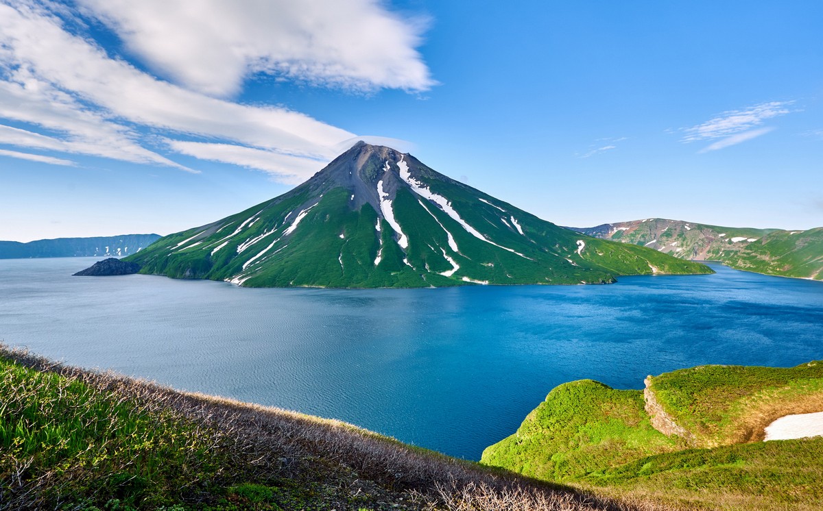
Yes folks, this is the one – the ultimate, the very best of all the best must-see places on the planet, including all my Top-100 places. It is the King of the Volcanoes – Krenitsyn volcano, on the volcanic island of Onekotan – one of the Kurils:
And when I say it’s the most beautiful place on the planet, I reckon it could very well be yours too – if you were ever to behold it. For “I’ve been around”, as it were. I’ve been globetrotting for the last quarter-century visiting a great many places on business while also getting to see what those places have on offer in terms of their sights of interest and beauty. I’ve also been on a great many vacations to some of the more unusually beautiful places on the planet. So, to come top of my list – trying not to blow my own trumpet as much as I can – really should stand for something. I hope so, anyway!…
I wrote in the previous paragraph “if you were ever to behold it”. For it’s true that Krenitsyn’s a real pain in the posterior to get to. But this fact brings us one of the main reasons why it’s so awesome and top-of-the-list: there’s normally absolutely no one else there – ever! It’s a totally exclusive experience – just for you and your posse. Oh yes!
As I’ve explained before, Krenitsyn is a complex hydro-technical structure. In short, it’s a volcanic island on a volcanic island. Like so:
 (Drone photos by Chris Burkard)
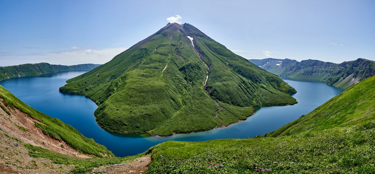
The ancient volcano collapsed (which is a normal phenomenon in the long life of a volcano), leaving a huge caldera in its place, inside of which a new incarnation has been growing. And since plenty of snow falls here of a winter – not to mention all the (darn!) rain – in the caldera around the new cone is a ring-shaped lake. Accordingly it’s called Koltsevoe, which means “ring”. And what a sight it is to see! Especially when the inner volcano’s peak is topped with a mini-cloud:

From outer space the spectacle is just as fantastic:

The sizes involved are just as impressive as the shapes and contours:
- The diameter of the caldera: seven (7!) kilometers long!
- The width of the base of the caldera (externally, shore to shore): 17+km!
- The height of the caldera: from 540 to 900m;
- The height of the lake: 400 meters above sea-level (that is, from the ridge of the caldera to the lake there’s a drop of 150-500m);
- The depth of the lake: 369 meters;
- The height of the volcano: 1324m (that is, from the level of the lake – 924 meters);
- The width of the base of the volcano at the level of the lake: around 3.5km.

Here are a few more pics by Chris Burkard taken on our expedition here in 2019:


Of course, any self-respecting meditation-minded adventure tourist wants just one thing when he or she sees this spectacle: to get up to the top of the inner volcano!

To do so, first you take one of the three tracks up to the top-ridge of the caldera, then it’s down the inside of the caldera, then it’s across the lake, then it’s up the volcano. It all sounds so simple. I’ll get to the details in a bit to show you it’s not!…

One thing making such a volcano-venture not simple: in addition to the usual tents, food & drink, cooking/dining inventory, clothing, ropes, jumars and assorted other climbing kit, you need to take with you a boat to cross the lake.
And of course, you can only undertake the venture in good weather. If it’s not good, you sit and wait till it is – something I’ve christened the Strategic Stratovolcano Stratagem: you get up to the top of the caldera, put up the tents, and start the inevitable wait :).

…And eventually a wind picks up and blows away the mist and… it all becomes sooo worth it ->

Alas, the stratagem… didn’t work this time. It does work – but only when faced with a one-off cyclone. When there are two in a row – the sit-and-wait seems to take forever.
You may be wondering why everything has to be so difficult: why don’t we just take a helicopter? Well, we could, since Kamchatkan travel agencies do cater to the more chopper-inclined. However, we wanted to do it… properly. A climb up the King of the Volcanoes should entail some difficulty and discomfort – it’s simply the right thing to do, IMHO ).
But back to the cyclones…
The first one came and went. The wind appeared to be blowing away the murkiness (which was still present but expected to dissipate soon), so off we popped…

It was into the dinghy and heading toward the outer shore of the caldera…

No quay or moorings here, of course, since this is an uninhabited island: zero infrastructure. I say uninhabited, but that’s not quite true: it is inhabited by plenty of… foxes! Surprisingly though – not a single seal…

There are two ~paths you can take to get up the outer slopes of the caldera: the short path (8km) from the east, or the long path (15km) from the west. We took the latter, since there were some seriously choppy seas to the east after a storm that made a landing there too risky. Incidentally, there is a third, short ~path being cut through the dense overgrowth, also from the west, but as of August 2022 it’s still not finished, and we didn’t want to have to cut through the remaining said dense overgrowth ourselves – way too much hard work (I like a challenge, but there are limits!).
The track starts out hugging the shore of a stream – like this:

A little further the track coincides with what remains of a former military road. All around – tundra, or what looks like tundra: no trees, flat landscapes, moss and grass:

Despite the fact we’re on the 50th parallel – just like Paris and most of the Canada-U.S.A border – the climate here is way harsher – subarctic even. But the going today is gentle and comfortable: the path’s not bad and not too steep:

Ruins of some kind of shacks dot the landscapes – and we decide to take a breather at one of them:

Goodbye ship; see you soon!… ->

Half-way along the track – a freshwater stream. We fill up our canisters here, for this is the last spot where there’s fresh drinking water – save for a few ponds here and there, or in the caldera-lake (but we sure didn’t fancy clambering all the way down there):

We climb higher – the views becoming all the more grandiose:

The inside caldera comes into view ->

We make it to the top-rim of the crater!

There are plenty of places suitable – i.e., nice and flat – for pitching tents. And if we can’t all fit on one piece of suitably flat “lawn”, there’s another not too far away…

…There are also plenty of dry twigs and bushes to be found for making a camp fire. In all – near the top of a colossal collapsed volcano, the conditions for a spot of camping are really very comfortable. Who knew? :)
And the view from up above (from a drone):

We’re just over the horizon in this pic – marked with the red arrow. You can see just how tricky it is finding the right place to make the descent down to the lake…

Next up: down the caldera, and across the lake to the “beach” over there ->

Then up the rubble on the volcano ->

…All so as to be able to get to the top by lunchtime:

…That was the plan, anyway. // For those curious about what the alternative route is like, check this out.
// WARNING! Doing Krenitsyn is categorically not suitable for… couch potatoes! It requires both strength and endurance to be able to manage it physically, and also a good dose of “grit” to be able to handle it mentally-morally!…
In our group there were just the two guides who had plenty of experience climbing Krenitsyn – and who were also very physically fit, while just two of the tourists were as-fit-as-fiddles just like the guides. The rest of the group were less-than-very-fit “office plankton”. They weren’t too badly out-of-shape – they do the odd run or go to the gym occasionally, but still – there’s “reasonably fit”, and then there’s “fit enough to go up – and come back down again (alive!) from – a Krenitsyn mega-trek!” We had to gauge the difficulty just right and make sure our group’s overall fitness level would be sufficient. Accordingly, to be on the safe side, we sent a reconnaissance group – made up of the two guides – a month earlier to identify the best route for us sedentary-lifestylers )…
To the reccy group – a big thank you! Not only did they find the route up-and-down that was just right for us, they also cleared away plenty of bushes along the route (so we could later conserve precious energy), and brought with them 300 meters of safety ropes plus a catamaran! Their reccy-mission also saw them cross the lake and climb to the top of the volcano to hide there a bottle of celebratory single malt (which would be added stimulus for us to get to the top)!
But back (rather – forward) to us atop the caldera, awaiting the following day’s ascent…
…Suddenly, “Houston, we have a problem”: our catamaran had been chewed up by the foxes! No doubt the unusual smell of fresh plastic attracted them. They’d even chewed the oars too – but not so bad as to render them useless. Which couldn’t be said of the catamaran itself – unrepairable out in the field (. But all was not lost: there was a spare back on the ship! Two volunteers raced back to the ship to get it, while the rest of us had another afternoon of rest, relaxation and meditation.
…We took some pics too ->

That’s an interesting photo: the peak of the actual volcano appears to be hidden by cloud, while in its reflection you can see the peak cloud-free!
Strolling around the caldera top, we came across this here stone column. What is it? And why was it brought here? It wasn’t here three years ago…

Even with its peak shrouded in cloud – Krenitsyn’s still monumentally magnificent! ->

…And meditative ->

No wind whatsoever, still water – the reflections perfect:

Suddenly – a discarded life-jacket. A sign that folks do walk around up here occasionally. There’s no excuse for littering though – ever; but especially here ->

The view toward the Sea of Okhotsk:

Sometimes the volcano vanishes behind the cloud completely! ->

Mostly though it was just the upper-half of the volcano that was obscured by clouds:

Check out this reflection:

“We get good weather here, but the climate is severe,” is a phrase popular among locals in Kamchatka. It pretty much applies to the Kuril Islands too. There’s also: “You’ll find out the weather for tomorrow the day after tomorrow!” That sure used to be the case, but, of late (given technological advances in meteorology) – a lot less so. Tomorrow’s weather – and the day-after-tomorrow’s – can be reasonably accurately forecast; however, how it’ll be thereafter is anyone’s guess; you might as well toss a coin!
The harshness of the climate and the tundra expanses on the 50th parallel can be explained easily: the Gulfstream pumps warm water up into the Arctic Ocean. So, if warm water goes there, the water that’s there in the first place needs to be released somewhere else. Where? That’s right – cooled Arctic Ocean seawater is pushed down through the Bering Strait and heads south toward Kamchatka and the Kurils (and it’s called, among other things, the Kurile Current). So, given the cold water here, plus the “warm” water coming from the Sea of Okhotsk (which they call the “Fridge of the Far East”), what you get is one of the world’s harshest, wettest climates.
// I sometimes imagine how different things would be here if the Gulfstream went in the opposite direction: warm air from the tropics coming in toward the Kurils and Kamchatka. The Kurils would be all palm trees and resorts and hotels. Meanwhile Europe would resemble the Kurils – an undeveloped tundra backwater ).
The wind direction here decides a lot. Remember – there’s only cold water around here. So what happens when the wind comes up from the south? It brings in moist subtropical air from the direction of Japan. And what happens when warm air meets cold water? Yes – you get condensation. Therefore, be prepared for rain and the resulting tourism let-downs. If there’s a wind from the east, -> hot air and cyclones. If from the west (from the Sea of Okhotsk), there could be anything from sunny days to raining-cats-and-dogs days (or even… smoke: blown across from forest fires on the mainland – like last year in Kamchatka. But it’s only when wind comes from the north here that it’s fairly guaranteed that it’ll be sunny weather. And, talking of a northerly wind, here’s a time-lapse of one shooing cloud away off Krenitsyn:
Meanwhile, we sit and wait, wondering if tomorrow will deliver the expected good weather…

Upon waking the following morning, things were looking promising – and astonishingly beautiful:


We decided to go for it. Down the inner slope of the caldera we went. A mere 150m down vertically, but we used 300m of rope in all down the slope. In places it got very steep:


Next – the catamaran. Two crossings – four persons each time:


The water in the lake – so clean and clear ->

The second “shuttle” makes it to the other shore – crossing the 700 meters of lake ->


We begin our ascent…

The going at first – steady and comfortable ->

But the comfort didn’t last. Soon it got steep and rugged and fairly horrid… ->

The earth under our feet becomes annoyingly, dangerously loose; the going – all the more tough. We stop for a breather ->

…The view – not bad at all; could have been better though…

Soft moss – perfect for sitting on. But its presence didn’t last long either…

Finally – after six hours of physical exertion – we make it to the top! Hurray!… The views all around – OMG! ->


Alas – the clouds were back. We launched the drone and steered it some 400 meters up – but it still couldn’t rise higher than the clouds. Some of the pics it took were unusually impressive, all the same ->

We waited up top some two hours with great expectations, but, alas – no sun appeared. We decided to head back down…


So there you have it folks. Krenitsyn – done. Highly recommended – if you’re the fit, adventurous type, naturally )…

PS: the lake is completely… lifeless! No fauna or flora whatsoever. Why? Volcanic emissions into it? No birds fancy flying down into the caldera bringing flora with them? There are other more comfortable lakes nearby, after all…
The only life the lake had seen in a long while was… ->

PPS: video material – coming up later (stay tuned)!…
That’s all from Krenitsyn folks. Back soon with more tales from the Kurilian side…
The rest of the snaps from our Kurils-2022 expedition are here.

