July 29, 2015
Icelandic tectonic.
Everyone’s got a basic idea of how this planet of ours is constructed, even primary school kids. It goes something like this: in the middle of the planet is the core – the nucleus; then there’s the mantle, and on the outside there’s the hard crust, upon which you’re reading this blog.
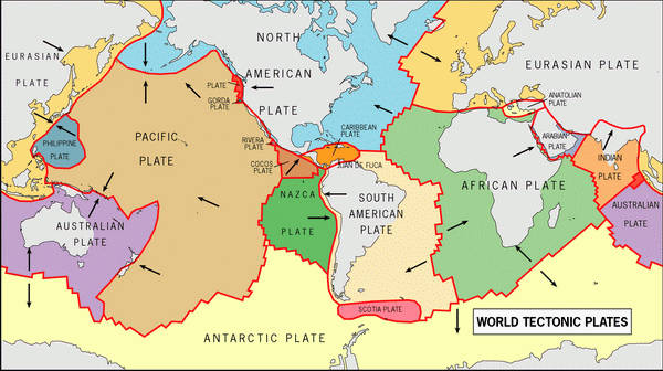
But the earth’s crust isn’t a single whole piece – it consists of tectonic plates, which float around mostly imperceptibly on the surface of the magma. And they float around in different directions – into one another, perpendicularly, or away from each other. That is, they converge, chafe one another, or diverge from one another. Along the edges of the plates there are frequent earthquakes and all sorts of volcanic activity. For those interested, check out the links above.
Where plates converge are to be found mountains, volcanoes, and their associated features of terra firma. We’re talking: Japan, Kamchatka, the Kurils, the Aleutians, the Andes, the Cordillera, the Himalayas, etc. Places where plates diverge are usually are on the seabed, visible on maps of sufficient quality and detail: here, under the Atlantic for example is the Mid-Atlantic Ridge. It’s here where tectonic plates move away from one another, with the space between them being filled with magma.
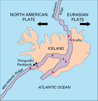
One of the few places where this divergence of plates occurs on land is Iceland: it’s situated along the seam between the North American and Eurasian plates. The former is moving ever-so slowly to the west, the latter ever-so slowly to the east – at a speed of 2cm a year. That is, the width of Iceland increases by two centimeters every year (not taking into account coastal erosion or, just the opposite, the expansion of the land mass on account of lava flows). 2cm a year – that’s two meters a century, 20 meters a millennium, 20 kilometers in a million years. So, if things keep going as they do, in 200 million years Iceland will become the length of Chile, and in in 300 million – the length of Russia!
The crack in the ground along the fault line is best observed in Iceland at Þingvellir (Thingvellir).
There’s an uneven and craggy crack around five kilometers long that crosses the landscape here, plus a nice lake. This is how it all looks:
Those mountains there on the horizon – they’re in Europe. The pic was taken in North America, and all the land between us is the gap between the two tectonic plates – the Eurasian and North American.
It’s not just tectonics this place has in spades. It turns out that this place is also the cradle of the Icelandic state, democracy and orthodoxy. It was here from 930A.D. Western Europe’s oldest parliament (Althing) was founded; here in the year 1000 where Christianity was adopted; and here in 1944 where the independence of the country was declared. Right here:
If ever you’re in Niceland – don’t miss this place! It’s handy too: it’s only 50km from the center of Reykjavik.
Tectonic plates aside, Iceland has plenty of canyons too. Be they big canyons or mini-canyons, they’re always breathtakingly beautiful canyons. Like, for example, Fjaðrárgljúfur. It’s here. And it looks like this:
https://instagram.com/p/4r9jQ2OiaW/
Here’s some more detail about the canyon, but you might need a magnifying glass:
One interesting thing about the place (besides its natural beauty, of course) is how all the most interesting uphill paths that run off the main canyon all have signs by them warning that visitors shouldn’t go up them as the ground’s too slippery. However, the signs seem to be mostly ignored, as right past them there are always well-trodden paths made by tourists confident enough to take the risk.
Well, if you can’t beat ’em, join ’em. So we risked out lives too in the face of that particularly dangerous threat of… slippery ground. I also had a beer up on a thin crest of one of the hills. It was then I ‘got’ the signs. They should have given ‘it’s easy to topple off the tops!’ as the reason to warn not to pass. For some hundred meters up, on a ridge just a meter wide and a wind blowing – hmmm, not the safest, after all. Just make sure you’re wearing sensible walking boots if you must go up onto the tops…
Next we drove to our lodgings for the night, taking in the scenery and merrily snapping away. Some of the natural phenomena I’ve already mentioned, others – below. We stayed in the coastal village of Vík (here), which has only 300 inhabitants, but where there are five hotels and nine restaurants. The whole population of the village could fit in all those!
… Back to those natural phenomena I’ve yet to mention: rocks and crags and cliffs and peninsulas and sea stacks; examples: Dyrhólaey, Reynisdrangar and the Reynisfjara volcanic beach. Here they are:
https://instagram.com/p/5d4n5JOidx/
On the horizon – Dyrhólaey cliffs:
… and here’s Eyjafjallajökull:
Here are some Icelandic puffins. More on these and other Icelandic animals coming up in a future post…
https://instagram.com/p/5Yw__1OidA
Also coming up will be reports on glacial Iceland and waterfall Iceland. Sadly we only covered around a quarter or fifth of the whole of Iceland’s beauty and natural amazingnesses, but what we did see – you’ll see it too :).
In among the three-quarters or four-fifths of stuff we didn’t see but which is only a stone’s throw from Reykjavik (aaargh!) there’s a totally unique volcanism attraction. Tourists are actually allowed into the crater of the sleeping Thrihnukagigur volcano! It’s here. I just have to get there next time. Check out the photos.
And on that photographic note, I’ll mention that the rest of the photos are here, and say bye-bye – until next time folks!…


